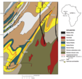
Fael:USGS geologic map Ghana.png
Bɔbew

Dza erohwɛ yi ne kɛse: 620 × 599 pixels. kɛseyɛ bɔbea afofor: 248 × 240 pixels | 497 × 480 pixels | 953 × 921 pixels.
Fael nankasa (953 × 921 pixels, fael ne kɛse: 241 KB, Nsɛnkyerɛdze asɛnka ahorow: image/png)
Fael abakɔsɛm
Mia da/ber no do na hwɛ mbrɛ nna fael no tse dɛm ber no.
| Da/Ber | Tɔfabɔ | Bɔbew nsusui | Dwumadzinyi | Nkasaho | |
|---|---|---|---|---|---|
| dza ɔwɔ do | 12:26, 5 Ɔberɛfɛw 2018 |  | 953 × 921 (241 KB) | Pi3.124 | User created page with UploadWizard |
Fael no dwumadzi
Kratafa a odzidzi do yi dze dɛm fael yi yɛ edwuma:
Wiadze mfɛndzanan fael dwumadzi
Wikis afofor a wɔka do yi dze dɛm fael yi dzi dwuma:
- Yɛdze dzi dwuma wɔ en.wikipedia.org
- Yɛdze dzi dwuma wɔ fr.wikipedia.org
- Yɛdze dzi dwuma wɔ ha.wikipedia.org
- Yɛdze dzi dwuma wɔ id.wikipedia.org
- Yɛdze dzi dwuma wɔ uk.wikipedia.org
- Yɛdze dzi dwuma wɔ www.wikidata.org
- Yɛdze dzi dwuma wɔ zh.wikipedia.org

